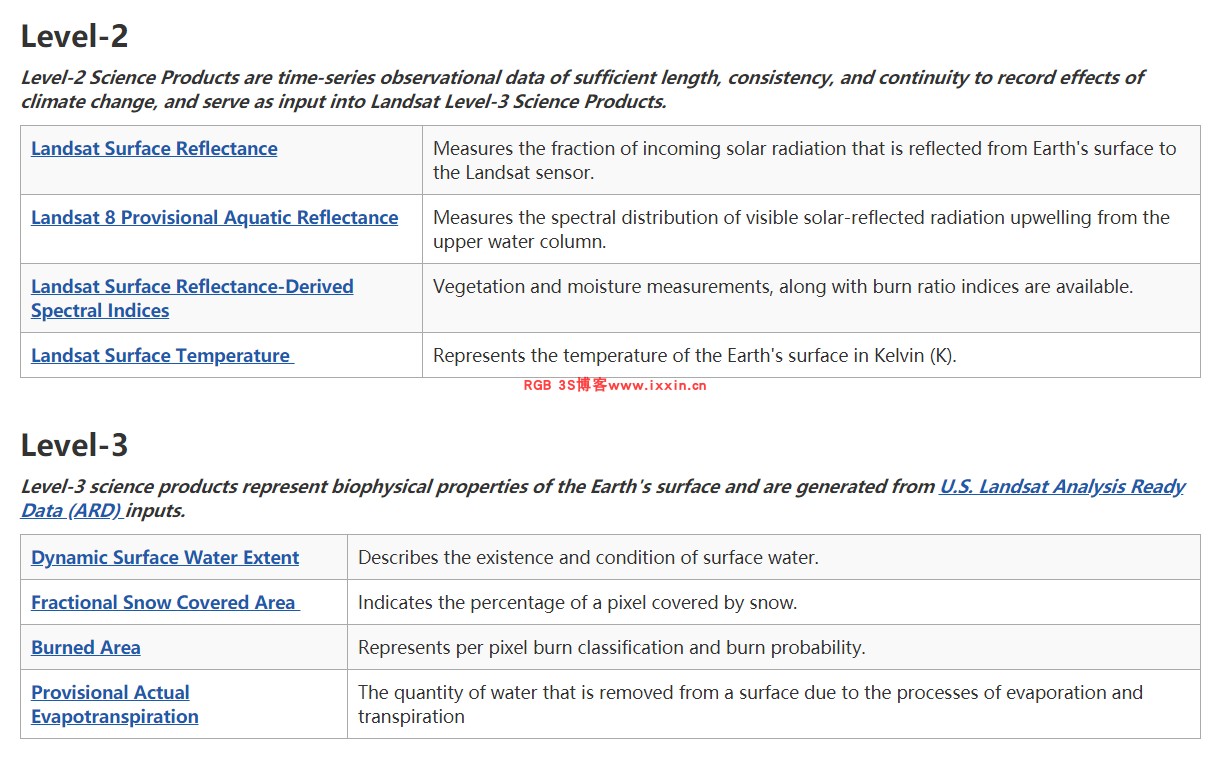
USGS已经提供的科学产品列表:
目前的产品生产范围主要是美国本土区域,期待Collection 2 全球产品。
蒸散发产品原文链接:
Landsat Provisional Actual Evapotranspirationhttps://www.usgs.gov/land-resources/nli/landsat/landsat-provisional-actual-evapotranspiration?utm_source=twitter&utm_medium=social&utm_term=e9675928-1276-44aa-a3d2-421c1f965cd3&utm_content=&utm_campaign=usgslandsat&tdsourcetag=s_pctim_aiomsg
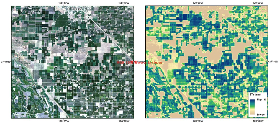
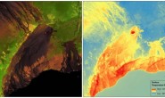
Example of Landsat Provisional Actual Evapotranspiration for agricultural fields near Merced, California in the San Joaquin Basin, using data acquired by Landsat 8 (Path 43 Row 34) on July 31, 2019; Left: Natural Color Surface Reflectance Image, Right: Actual Evapotranspiration Image.
Landsat 8 (Path 43 Row 34) 2019年7月31日获取的数据,在圣华金盆地加利福尼亚默塞德附近的农田的Landsat临时实际蒸散量示例; 左:自然色表面反射图像,右:实际蒸散图像。
产品获取:
ETa will be available on-demand via the USGS EROS Center Science Processing Architecture (ESPA) interface for Landsat 4-5 Thematic Mapper (TM), Landsat 7 Enhanced Thematic Mapper Plus (ETM+), and Landsat 8 Operational Land Imager/Thermal Infrared Sensor (OLI/TIRS) scenes acquired over the conterminous United States (CONUS) that can be successfully processed to a Collection 1 Provisional Surface Temperature product. ETa products are available to order about 4 days after acquisition.
Although the ETa algorithm is designed to be applied globally, the current implementation uses auxiliary data that are constrained to the CONUS.
ETa将通过USGS EROS中心科学处理体系结构 (ESPA)接口按需提供,以用于Landsat 4-5 (TM),Landsat 7 (ETM+)和Landsat 8 (OLI, TIRS)。 在美国本土(CONUS)上获取的(OLI / TIRS)场景可以成功处理为“集合1”临时表面温度产品。 收购后约4天即可订购ETa产品。
尽管将ETa算法设计为在全球范围内应用,但当前的实现方式使用的约束条件是CONUS辅助数据。
包含内容:
ETa are generated at the 30-meter spatial resolution. The default projection system for all Landsat science products is Universal Transverse Mercator (UTM), but other projection systems are available through the ESPA On-Demand Interface. The default file format is Georeferenced Tagged Image File Format (GeoTIFF), but options for other data format delivery are available. More information on Landsat output formats supported by ESPA is available in the ESPA On-Demand Interface User Guide.
Actual Evapotranspiration (ETa): Provides a per-pixel estimate of daily water transfer from the Earth’s surface to the atmosphere in units of water depth in millimeters (mm).
ET fraction (ETf): Represents unitless fraction of ETr, nominally varying between 0 and 1 (in SSEBop model the maximum ET fraction is 1.05). This can be used in combination with user provided reference ET (ETr) to create a more accurate ETa which takes into account local weather conditions.
Percent Uncertainty: Provides an estimate of percent uncertainty using the input ST uncertainty and the psychrometric constant.
ET Uncertainty (ETUN): Provides ET product uncertainty in units of water depth (mm) using the Percent Uncertainty value and ETr auxiliary data.
ET Quality Assessment (ETQA): Provides high-level information about the confidence of the ETf calculated.
Pixel Quality Assessment (pixel_qa): The bit combinations that define certain quality conditions. More information about Pixel Quality Assessment can be found in the Landsat 8 Land Surface Reflectance Code (LaSRC) Product Guide and the Landsat 4-7 Surface Reflectance Product Guide
Metadata: Includes Landsat scene information in XML format.
ETa以30米的空间分辨率生成。所有Landsat科学产品的默认投影系统是通用横轴墨卡托(UTM),但其他投影系统可通过ESPA按需界面使用。默认文件格式为“地理参考标记图像文件格式(GeoTIFF)”,但其他数据格式交付选项可用。 《 ESPA按需界面用户指南》中提供了有关ESPA支持的Landsat输出格式的更多信息。
实际蒸发蒸腾量(ETa):提供水每天从地球表面到大气估计值,单位为毫米(mm)。
ET分数(ETf):代表ETr的无单位分数,名义上在0和1之间变化(在SSEBop模型中,最大ET分数为1.05)。可以将其与用户提供的参考ET(ETr)结合使用,以考虑到当地的天气状况,创建更准确的ETa。
不确定度百分比:使用输入的ST不确定度和湿度常数提供不确定度百分比的估计。
ET不确定度(ETUN):使用“不确定度百分比”值和ETr辅助数据以水深(mm)为单位提供ET产品的不确定度。
ET质量评估(ETQA):提供有关所计算的ETf的置信度的高级信息。
像素质量评估(pixel_qa):定义某些质量条件的位组合。有关像素质量评估的更多信息,请参见《 Landsat 8陆地表面反射率代码(LaSRC)产品指南》和《 Landsat 4-7表面反射率产品指南》。
元数据:包含XML格式的Landsat场景信息。