翻译:RGB-3S Blog XXIN

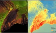
Left: Land surface reflectance natural color composite image (bands 4,3,2); Right: aquatic reflectance Band 2 (Blue band) image of San Francisco Bay, using data acquired by Landsat 8 (Path 44 Row 33) on October 7, 2018
左:真彩图,右:Band2的水体反射率,洛杉矶影像,Landsat-8 2018 10.7日获取
Landsat 8 Provisional Aquatic Reflectance is a provisional science product with the potential to make contributions to aquatic science and environmental monitoring capabilities for aquatic ecosystems, especially in coastal environments and inland water bodies.
Landsat’s medium spatial resolution provides the capability to map optically active components of upper water column in inland and near-shore waters. Ocean color, defined as the spectral distribution of reflected visible solar radiation upwelling from beneath the water surface, has revolutionized the field of aquatic remote sensing research. The applications of ocean color remote sensing are extensive and fundamental to understanding and monitoring both marine and freshwater ecosystems.
The Landsat 8 Provisional Aquatic Reflectance product is derived from Landsat 8 Level-1 (L1) reflective bands over water bodies. Top of Atmosphere (TOA) reflectance and auxiliary atmospheric data are input to an atmospheric correction algorithm to retrieve the water-leaving radiance at visible wavelengths. The water-leaving radiances are then normalized by downwelling solar irradiance to remove the remaining effects of solar orientation and atmospheric attenuation to produce spectral remote sensing reflectance (Rrs) for visible bands. Finally, the Rrs visible bands are normalized by the Bidirectional Reflectance Distribution Function (BRDF) of a perfectly reflecting Lambertian surface (multiplied by π) to produce dimensionless Aquatic Reflectance. The atmospheric correction algorithm used to generate Landsat 8 Provisional Aquatic Reflectance products is based on the Sea-viewing Wide Field-of-View Sensor (SeaWiFS) Data Analysis System (SeaDAS) package distributed by NASA’s Ocean Biology Processing Group.
Landsat 8 Provisional Aquatic Reflectance products are generated at 30-meter spatial resolution. The default projection system for Landsat science products is Universal Transverse Mercator (UTM), but other projection systems such as Albers Equal Area (AEA), Sinusoidal, Geographic, and Polar Stereographic (PS) are available through the ESPA on-demand interface as a customized service.
Landsat 8临时水反射率产品是一种临时科学产品,有潜力为水生生态系统(尤其是在沿海环境和内陆水体中)的水生科学和环境监测能力做出贡献。
Landsat的中等空间分辨率可绘制内陆和近岸水域的海洋水色地图。海洋水色定义为从水面上反射的可见太阳辐射的光谱分布,其彻底改变了水生遥感研究方式。海洋水色遥感的应用对于理解和监测海洋和淡水生态系统是广泛且至关重要的。
Landsat 8临时水反射产品来自水体上的Landsat 8 Level-1(L1)反射率波段。大气顶部(TOA)反射率和辅助大气数据被输入到大气校正算法中,以检索可见波长处的离水辐射率。然后与下行太阳辐射来计算归一化出水辐射率,并消除太阳角度和大气衰减等其他影响,以得到可见波段的遥感反射率(Rrs)。最后,Rrs可见带通过完全反射朗伯表面(乘以π)的双向反射分布函数(BRDF)进行归一化,以产生无量纲的离水反射率。
Landsat 8临时水反射产品是在30米的空间分辨率下生成的。Landsat科学产品的默认投影系统是通用横轴墨卡托(UTM),但其他投影系统(例如Albers等面积(AEA),正弦,地理和极地立体(PS))可通过ESPA按需界面作为定制服务。
Note: These data are provisional and are subject to revision. They are being provided to meet the need for timely best science. The data have not received final approval by the U.S. Geological Survey (USGS) and are provided on the condition that neither the USGS nor the U.S. Government shall be held liable for any damages resulting from the authorized or unauthorized use of the data.
注意:这些数据是临时的结果,可能会进行修订,提供它们是为了满足及时科学的需求。该数据尚未获得美国地质调查局(USGS)的最终批准,其提供的条件是,USGS和美国政府均不对由于授权或未经授权使用数据而造成的任何损害承担责任。
Data Access
Landsat 8 Provisional Aquatic Reflectance products are available through the USGS EROS Center Science Processing Architecture (ESPA) on-demand interface. Additional customization services such as reprojection, spatial subsetting, and pixel resizing are also available via ESPA.
Further information about ESPA’s processing options can be found in the ESPA On-Demand Interface User Guide.
Visit the Landsat Data Access web page for information about bulk download options.