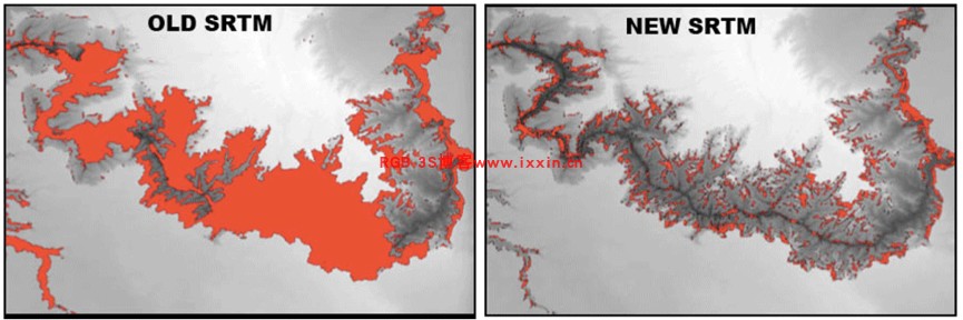
A new global digital elevation model (DEM) has been released. NASADEM is a reprocessing of Shuttle Radar Topography Mission (SRTM) data to improve height accuracy and to infill missing elevation data. The data was improved through the use of algorithms and data that wasn’t available at the time of the original SRTM data release. Missing data within SRTM was refined with ASTER GDEM elevations.
一种全新的全球DEM已经发布了,NASADEM是SRTM的再处理,提高了高程精度以及填充了缺失值。此数据使用了之前数据不具备的算法和数据。对于缺失数据使用ASTER GDEM进行填充。
From NASA‘s technical details about the process:
NASA关于处理的具体技术细节:
We will reprocess the entire SRTM dataset from raw sensor measurements with validated improvements to the original processing algorithms. We will incorporate GLAS data to remove artifacts at the optimal step in the SRTM processing chain. We will merge the improved SRTM strip DEMs, refined ASTER and GDEM V2 DEMs, and GLAS data using the SRTM mosaic software to create a seamless, void-filled NASADEM. In addition, we will provide several new data layers not publicly available from the original SRTM processing: interferometric coherence, radar backscatter, radar incidence angle to enable radiometric correction, and a radar backscatter image mosaic to be used as a layer for global classification of land cover and land use.
The newly available NASADEM data products are available with a 1 arc second resolution. Other radar products were released with the updated DEM. All NASADEM products are available for land between 60° N and 56° S latitude, representing 80% of all the Earth’s landmasses. All datasets can be downloaded from NASA’s Land Processes DAAC (LP DAAC)
新的NASADEM数据是1弧秒分辨率,覆盖地球的80%,从北纬60度到南纬56度,可以从LP DAAC下载。
数据下载
可以从EARTHDATA进行下载:
直接搜索NASADEM即可

原文地址:https://www.gislounge.com/updated-global-elevation-data-released-by-nasa/amp/